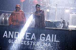
Andrea Gail. Satori. Tamaroa. Hannah Boden.
Names that probably mean little to many people…but for some of us, the emotion felt in the gut more than 20 years later is as raw and powerful as the days we learned of them in October 1991.
As many of my readers and Facebook friends know, I was raised on the ocean. My family arrived in New York in colonial days as Dutch sea captains, and, but for a single young brother who stayed home in port, my ancestors were lost to the ocean they loved in 1705 when the Castel del Rey shipwrecked outside New York Harbor in a sudden ice storm.
For my part, the ocean was generally a far gentler mistress. Growing up on Long Island’s south shore, swimming in the ocean, clamming in the bays, fishing with my grandfathers, partying at remote bayhouses, walking on (and occasionally falling through) the ice of frozen canals, and exploring expanses of salt marshes and mudflats that no sane person would venture on were all just a part of growing up. And even when a rip current once took me for a ride, I never really felt fear.
In 1990, I moved to Martha’s Vineyard and took on a state job as the island’s Transportation Program Manager. Being an island, ‘transportation’ largely took the form of ferry and boat traffic, bicycles, and finding new and exciting ways of cramming 100,000 cars on an island designed for ten percent of that in July. Because no one simply arrives on – or flees from - an island quite as easily as on the mainland, our office was also the civil defense headquarters for the Vineyard.
The ocean decided to take it.
It was October 1991, and it was the only hurricane in recent times that the National Weather Service chose not to name. Many people refer to it as “The October Hurricane,” or “The Hallowe’en Nor’easter,” but Vineyarders would always call it the “No-Name Nor’easter.”
 Author Sebastian Junger would popularize the phrase, “The Perfect Storm,”
and chronicle the events of those days with impeccable, moving detail in his
book (and subsequent movie) by that name.
Author Sebastian Junger would popularize the phrase, “The Perfect Storm,”
and chronicle the events of those days with impeccable, moving detail in his
book (and subsequent movie) by that name.The storm was birthed when a typical winter nor’easter absorbed the remnants of Hurricane Grace in a process that exploded on October 28, 1991 off of Nova Scotia. By November 1 the system evolved into a full-fledged hurricane with peak winds of 75 miles per hour (120 km/h), but the National Hurricane Center chose to leave it unnamed. The toll on New England, New York, New Jersey, and people’s lives had already occurred.
The Andrea Gail, a fishing boat out of Gloucester, had tried to turn home from the Flemish Cap, the eastern-most edge of the Grand Bank fishing grounds, on October 24 – heading directly into the meterological equivalent of two textile mill rollers, pulling in and flattening everything in its path. It had been mentioned by fishermen that 35-foot seas was enough to scare even the most hardened seafarer. The buoys off of Nantucket were registering 75 foot seas. Further along towards the George’s bank, those waves rose more than 100 feet – some 30 feet higher than the top of the Andrea Gail’s highest mast.
Contact with the six-man crew ceased on October 28.
Meanwhile, off the shore of Montauk, Long Island, an Air National Guard helicopter ran out of fuel and crashed in its efforts to find another boat, the Satori; the Cape Cod-based Coast Guard Cutter Tamaroa would be sent to rescue both crews. On the Vineyard, the waves were pulling out docks and boats to sea..and completely obliterating the northern entrance to Harthaven Harbor. Another boat was sinking off of Staten Island.
For many, I suppose, these are ‘stories’ they hear on the news, or tales that weather buffs like to tell.
For Islanders, for fishermen, for people who live in the pulse and fury of the sea…it is a much, much, deeper, almost primeval emotional connection. Every fisherman lost at sea on the Vineyard, or Nantucket, or from Gloucester or New Bedford brings an entire community into mourning in a way that is hard to describe to outsiders.
And so, our news folk tell us that almost 21 years to the day, Round Two is upon us. Hurricane Sandy is moving up the coast, where she will combine with a northeaster and a cold front. This time the resulting behemoth – being named “Frankenstorm” by some – will explode closer to land.
Sandy may crash into New Jersey or Delaware, which means the northeast storm quadrant – the harshest – will pound Long Island and New England. And this time, unlike the storm of 1991, it will occur during an astronomical full moon and high tide.
Or, she may follow a path similar to Hurricane Irene, which followed the Connecticut River Valley and dumped enough rain in western New England to devastate roads in Vermont, the Catskills of New York, and western Massachusetts.
I currently live in Shelburne Falls, Massachusetts, right on the Deerfield River. During Irene, the river rose some 15-20 feet, breaching its banks and destroying homes and businesses and much in its path. Massachusetts State Route 2 west of Charlemont was washed away. The Vermont landscape remains visibly scarred from the waters that scoured out valleys, collapsed banks, and carved new channels. Huge boulders I knew well from relaxing at Rock River in Newfane were literally pulverized into sand by the waters power.

Yesterday, the authorities-that-be were opening the dams to drain the river of as much water as possible in anticipation of “Frankenstorm.’ And I admit to feeling a combination of anticipation and unease as we wait…for us, but also for those on the greater waters.


